

San Jacinto Wilderness – Image Gallery


San Jacinto Wilderness
The San Jacinto Wilderness is a rugged and diverse mountainous area in Southern California, known for its towering peaks, lush forests, and stunning views.
Details
San Jacinto Wilderness
The San Jacinto Wilderness is located in Southern California, within the San Bernardino National Forest. This wilderness area covers over 30,000 acres and is home to the iconic San Jacinto Peak, which stands at 10,834 feet and is one of the highest peaks in the region. One of the most notable features of the San Jacinto Wilderness is the diverse range of habitats it encompasses, from pine forests to alpine meadows. The area is known for its stunning landscapes, including rugged mountains, deep canyons, and cascading waterfalls. The wilderness is also home to a variety of wildlife, including black bears, mountain lions, and bighorn sheep. Birdwatchers will appreciate the numerous species of birds that can be spotted in the area, including hawks, eagles, and owls. In terms of ecological significance, the San Jacinto Wilderness plays a crucial role in preserving the biodiversity of the region. The area serves as a refuge for numerous plant and animal species, some of which are rare or endangered. The wilderness also helps protect important watersheds and provides valuable recreational opportunities for visitors. Overall, the San Jacinto Wilderness is a haven for nature lovers and outdoor enthusiasts alike, offering a chance to explore and appreciate the natural beauty of Southern California.San Jacinto Wilderness
Points of Interest
Mount San Jacinto Peak
Mount San Jacinto Peak is the highest peak in the San Jacinto Wilderness, standing at 10,834 feet. It offers stunning panoramic views of the surrounding area and is a popular destination for hikers and climbers. The peak can be reached via several different trails, each offering a unique perspective of the wilderness.
Marion Mountain Trail
The Marion Mountain Trail is a challenging hike that leads to the summit of Mount San Jacinto Peak. The trail is known for its steep inclines and rocky terrain, making it a favorite among experienced hikers looking for a challenge. Along the way, hikers will pass through dense forests and alpine meadows, providing plenty of opportunities to spot wildlife.
Palm Springs Aerial Tramway
The Palm Springs Aerial Tramway is a popular attraction that takes visitors from the desert floor to the top of Mount San Jacinto in just a few minutes. The tram offers breathtaking views of the surrounding area and provides access to a network of hiking trails in the wilderness. The tram is a great way to experience the beauty of the San Jacinto Wilderness without having to hike to the summit.
Tahquitz Peak Fire Lookout
The Tahquitz Peak Fire Lookout is a historic structure located near the summit of Tahquitz Peak. The lookout offers stunning views of the wilderness and is a popular destination for hikers looking for a more leisurely trek. The lookout is still in use today during fire season, providing an important vantage point for spotting wildfires in the area.
San Jacinto Wilderness – Images

Description: Graphical representation of fire lines useful in forest fires, San Bernardino National Forest. The width of the lines varies from 30 to 60 feet.
Image by US Forest Service – Public domain – Wikimedia

Description: Fueled by hot, dry winds, the Lake fire has been spreading through California’s San Bernardino National Forest. The blaze, located about 130 kilometers (80 miles) east of Los Angeles, was first reported on June 17, 2015, and grew quickly on June 18. By the afternoon of June 22, the fire had burned 70 square kilometers (17,305 acres) and was 21 percent contained. The Advanced Land Imager (ALI) on the Earth Observing-1 (EO-1) satellite captured this false-color (short-wave infrared) view of the fire on June 20, 2015. Hot areas of active fires glow bright orange-red; relatively cooler areas of recently burned land glow dark red. When this image was acquired on June 20, the fire had burned about 60 square kilometers (15,000 acres) and was 10 percent contained. Westerly winds blew smoke away from Los Angeles, but caused smoke advisories to be issued in the Yucca and Morongo valleys to the east and the Lucerne Valley to the north. According to a June 22 news report, the fire was the largest to burn in a California national forest so far in 2015, and fire fighting costs were around $5 million. InciWeb reported that the fire was threatening about 500 structures, and evacuations were in place for all areas east of Angelus Oaks. Download full resolution and read more at <a href="http://earthobservatory.nasa.gov/IOTD/view.php?id=86092&src=flickr" rel="noreferrer nofollow">earthobservatory.nasa.gov/IOTD/view.php?id=86092&src=...</a> earthrightnow
Image by NASA Earth Observatory – CC BY 2.0 – Wikimedia

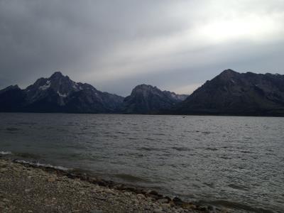
Description: Pine trees in the en:San Bernardino Mountains, CA, USA.
Image by Scottthezombie (talk) (Transferred by JaumeBG/Originally uploaded by Scottthezombie) – CC BY-SA 3.0 – Wikimedia

Description: U.S. Fish and Wildlife Carlsbad Office biologist, Clark Winchell, leads University of California San Diego student interns, Stella Yuan and Celeste Medina-Ontiveros as they survey flying squirrel territory. Photo by Joshua Allen Ray/USFWS.
Image by Pacific Southwest Region USFWS from Sacramento, US – Public domain – Wikimedia
Search
Quick Links
New Blog SystemNational Parks (NEW)
National Forests (NEW)
National Monuments (NEW)
National Recreation Areas
State Parks
Bureau of Land Management (BLM) Areas
Wilderness Areas (NEW)
By The Numbers (NEW)
- Populations of all Countries (NEW)
Ideas - Stock Tickers
Running USA Debt Total