Rain GaugeGrand Tetons LakeLaguna Beach SunsetHawaii Stormy Beach

Never Summer Wilderness – Image Gallery

The United States Congress designated the Juniper Dunes Wilderness in 1984 and it now has over 7140 acres. The Juniper Dunes Wilderness preserves the northernmost growth of western juniper, some of which have been around for 150 years, along with windswept sand dunes measuring 130 feet in height and 1200 feet in width. Other than junipers, no trees grow in significant numbers here, but many bushes and flowers bloom wondrously come spring, although the mountains that separate western and eastern Washington generally wring the moisture from the air.
The landscape here takes quite a battering; in fact, with strong southwest winds to build the dunes, seven to eight inches of precipitation to moisten them, a foot or so of snow that drifts down in winter, and summer temperatures that occasionally rise above 100 degrees Fahrenheit. Elevations range from 750 feet to 1,130 feet above sea level. But plenty of animals thrive despite the extremes: mule deer, bobcats, coyotes, badgers, skunks, weasels, porcupines, pocket gophers, kangaroo rats, several species of mice, hawks, owls, ravens, quail, partridge, pheasants, doves, numerous songbirds, and rattlesnakes.
The entire wilderness is surrounded by privately-owned lands. With permission, you can travel via old jeep trails that end near the boundary. Getting all the way to the Wilderness gate can be risky business, even with a high clearance 4-wheel drive vehicle (highly recommended), and there is a significant risk of getting stuck in the loose sand of the last jeep trail, Wilderness Road, especially in warm months when there is little moisture in the sand. One option is to park at the Off-Highway Vehicle staging area on Juniper Road (also a jeep trail) and walk an additional +1 mile to the Wilderness Gate.
This is absolutely necessary if you are pulling a trailer. You'll find no maintained trails and no water in the Wilderness, and backpackers and horseback riders should also be aware of the likelihood of large temperature variation for overnight stays.
Be sure to contact the BLM's Spokane District for the latest conditions and access to the spectacular Juniper Dunes Wilderness Area!
Directions:
Wilderness visitors must pack in all drinking water and be prepared for large temperature swings. Proper sun protection such as a wide-brimmed hat is recommended, even in early spring and late fall, along with sun screen lotion. There are no sources of ground water in the Wilderness.
Be aware that road access past the first "P" symbol (for "Parking") on the map when traveling northbound on Peterson Road (where Peterson Road ends and Juniper Dunes Road begins) is typically difficult due to loose sand road conditions and potentially some large roller-coaster like "whoops" in Juniper Dunes Road. Vehicle travel past this point normally requires, at a minimum, a high clearance vehicle, preferably 4-wheel-drive.
It is recommended that visitors to the Wilderness park their vehicles no farther up Juniper Dunes Road than the upper off-highway vehicle (OHV) "Open" area parking/staging area (identified on the map with the 2nd "P" symbol and "?" symbol), which itself is loose sand, and therefore potentially a place where vehicles could get stuck.
Access to the Wilderness Gate is via the one-mile stretch of Wilderness Road where it starts ¾ mile north past the upper parking/staging area off of Juniper Dunes Road. There is a Wilderness Road sign at that intersection but it is easy to miss. Travel on Wilderness Road requires a high clearance 4-wheel drive vehicle to reach the Wilderness Gate in the best of conditions, i.e. in late fall/ winter/early spring or soon after significant precipitation when the loose sand road has moisture and some compaction. As stated above it is recommended that people do not attempt turning off of Juniper Dunes Road onto Wilderness Road to access the Wilderness Gate, especially when sand conditions are dry. If you get seriously stuck it will be very difficult to get towed out.
Vehicles pulling trailers should never attempt driving past the upper OHV "Open" area parking/staging area. Visitors to the Wilderness can hike or ride on horseback across the OHV "Open" area from the upper parking/staging area to the Wilderness, or via Wilderness Road to access the Wilderness Gate.
The area is approximately seven miles northeast of Pasco, Washington. From Ritzville and Spokane, Washington:
US 395 South to Pasco. Exit onto Hwy 12 East (towards Walla Walla).
Just under 2 miles, exit onto Kahlotus Road (ramp north towards Kahlotus).
Continue NE on the Kahlotus Road for approx 5 miles.
Turn left onto Peterson Road. First 2 miles is Private Road.***Note: there is a huge yellow mailbox on the opposite side of Kahlotus Road at the entrance to Peterson Rd.
Continue straight approx 4 miles on Peterson Road. At the Juniper Road intersection, turn right.
Park in this area or continue for approximately 2 more miles.
There is a second large parking area with a metal information Kiosk at this point; this puts you next to the play area dunes. Be aware of sandy conditions in this parking area.
From here use an area map to get to the Wilderness Gate +1 mile away via Wilderness Road. Please sign in at the kiosk.
Contact:  
BLM Spokane District Office
1103 N. Fancher Road
Spokane, WA 99212
(509) 536-1200

<a href="https://www.blm.gov/visit" rel="nofollow">www.blm.gov/visit</a>
The Never Summer Mountains are a mountain range in the Rocky Mountains in north central Colorado in the United States consisting of seventeen named peaks. The range is located along the northwest border of Rocky Mountain National Park, forming the continental divide between the headwaters of the Colorado River in Rocky Mountain National Park to the local-east and the upper basin of the North Platte River (North Park) to the local-west; the continental divide makes a loop in these mountains. The range is small and tall, covering only 25 sq mi (65 km2) with a north-south length of 10 mi (16 km) while rising to over 12,000 ft (3,700 m) at over ten distinct peaks. The range straddles the Jackson-Grand county line for most of its length, and stretches into Jackson and Larimer county at its northern end. A panoramic view of the range is available from sections of Trail Ridge Road in Rocky Mountain National Park. One of the northernmost peaks, Nokhu Crags, is prominently visible from the west side of Cameron Pass.
The range is frequented by hikers and backpackers in the summer, and skiers and snowshoers in the winter. The area sees some mountaineering activity, but the rock tends to be rotten and the routes are dangerous. The Colorado River Trailhead in Rocky Mountain National Park has trails that lead to the Grand Ditch and remains of Lulu City. Trails from Cameron Pass lead to the Michigan Lakes, Lake Agnes and the Nokhu Crags area. Trails in nearby Routt National Forest lead to the Never Summer Wilderness on the western and southern edges of the range.
<a href="http://en.wikipedia.org/wiki/Never_Summer_Mountains" rel="noreferrer nofollow">en.wikipedia.org/wiki/Never_Summer_Mountains</a>

<a href="http://en.wikipedia.org/wiki/Wikipedia:Text_of_Creative_Commons_Attribution-ShareAlike_3.0_Unported_License" rel="noreferrer nofollow">en.wikipedia.org/wiki/Wikipedia:Text_of_Creative_Commons_...</a>
Never Summer Wilderness and Bowen Lake viewed from Cascade Mountain, June 2024.
Never Summer Wilderness sign above Bowen Lake in Arapaho National Forest, CO.
View of the Never Summer Wilderness from the ridge of Cascade Mountain above Bowen Lake, taken on June 27, 2024.


Never Summer Wilderness

The Never Summer Wilderness in Colorado is a stunning alpine wilderness area known for its rugged peaks, pristine lakes, and diverse wildlife.


Details

Never Summer Wilderness

The Never Summer Wilderness is located in north-central Colorado, encompassing over 20,000 acres of rugged mountain terrain. The area is named after the Never Summer Mountains, a range that forms the western boundary of the wilderness. This wilderness area is known for its diverse ecosystems, including lush forests of pine, fir, and spruce trees, as well as alpine meadows and high-altitude tundra. The landscape is dotted with crystal-clear lakes, cascading waterfalls, and rocky peaks that provide stunning panoramic views. The Never Summer Wilderness is home to a variety of wildlife, including elk, moose, deer, black bears, and mountain lions. Birdwatchers will also appreciate the chance to spot golden eagles, peregrine falcons, and other bird species that inhabit the area. One of the most popular attractions in the wilderness is the Baker Gulch Trail, a 9-mile hike that leads to Baker Pass and offers breathtaking views of the surrounding mountains. Other popular activities in the area include backpacking, camping, fishing, and wildlife viewing. Ecologically, the Never Summer Wilderness is significant for its role in preserving critical habitat for a wide range of plant and animal species. The area is also an important source of clean water for downstream communities, as the wilderness contains numerous headwaters that feed into the Colorado River. Overall, the Never Summer Wilderness is a pristine and untouched natural gem that offers visitors a chance to experience the beauty and serenity of Colorado's high country.


Never Summer Wilderness


Points of Interest

1. Bowen Lake

Bowen Lake is a stunning alpine lake located within the Never Summer Wilderness. The lake is surrounded by towering peaks and lush meadows, making it a popular destination for hikers and backpackers. Visitors can enjoy fishing, camping, and wildlife watching at Bowen Lake.

2. Mount Richthofen

Mount Richthofen is the highest peak in the Never Summer Range, standing at 12,945 feet. Hikers and climbers flock to Mount Richthofen to challenge themselves on its rugged terrain and enjoy breathtaking views of the surrounding wilderness. The peak is named after the famous World War I flying ace, Manfred von Richthofen.

3. Colorado River Trail

The Colorado River Trail is a popular hiking route that follows the scenic Colorado River through the heart of the Never Summer Wilderness. This trail offers stunning views of the river, as well as opportunities to spot wildlife such as elk, moose, and bald eagles. Hikers can choose to do a day hike or a multi-day backpacking trip along the Colorado River Trail.

4. Never Summer Mountains

The Never Summer Mountains are a prominent mountain range located within the Never Summer Wilderness. These rugged peaks are known for their dramatic cliffs, deep valleys, and abundant wildlife. Hikers can explore the numerous trails that wind through the Never Summer Mountains, offering a variety of challenges and stunning vistas.

5. Baker Gulch

Baker Gulch is a picturesque valley located in the Never Summer Wilderness. This lush valley is home to a variety of plant and animal species, making it a popular spot for nature enthusiasts. Visitors can hike, bike, or horseback ride through Baker Gulch to enjoy the beauty of the wilderness and soak in the tranquility of the surroundings.


Never Summer Wilderness – Images

The United States Congress designated the Juniper Dunes Wilderness in 1984 and it now has over 7140 acres. The Juniper Dunes Wilderness preserves the northernmost growth of western juniper, some of which have been around for 150 years, along with windswept sand dunes measuring 130 feet in height and 1200 feet in width. Other than junipers, no trees grow in significant numbers here, but many bushes and flowers bloom wondrously come spring, although the mountains that separate western and eastern Washington generally wring the moisture from the air.
The landscape here takes quite a battering; in fact, with strong southwest winds to build the dunes, seven to eight inches of precipitation to moisten them, a foot or so of snow that drifts down in winter, and summer temperatures that occasionally rise above 100 degrees Fahrenheit. Elevations range from 750 feet to 1,130 feet above sea level. But plenty of animals thrive despite the extremes: mule deer, bobcats, coyotes, badgers, skunks, weasels, porcupines, pocket gophers, kangaroo rats, several species of mice, hawks, owls, ravens, quail, partridge, pheasants, doves, numerous songbirds, and rattlesnakes.
The entire wilderness is surrounded by privately-owned lands. With permission, you can travel via old jeep trails that end near the boundary. Getting all the way to the Wilderness gate can be risky business, even with a high clearance 4-wheel drive vehicle (highly recommended), and there is a significant risk of getting stuck in the loose sand of the last jeep trail, Wilderness Road, especially in warm months when there is little moisture in the sand. One option is to park at the Off-Highway Vehicle staging area on Juniper Road (also a jeep trail) and walk an additional +1 mile to the Wilderness Gate.
This is absolutely necessary if you are pulling a trailer. You'll find no maintained trails and no water in the Wilderness, and backpackers and horseback riders should also be aware of the likelihood of large temperature variation for overnight stays.
Be sure to contact the BLM's Spokane District for the latest conditions and access to the spectacular Juniper Dunes Wilderness Area!
Directions:
Wilderness visitors must pack in all drinking water and be prepared for large temperature swings. Proper sun protection such as a wide-brimmed hat is recommended, even in early spring and late fall, along with sun screen lotion. There are no sources of ground water in the Wilderness.
Be aware that road access past the first "P" symbol (for "Parking") on the map when traveling northbound on Peterson Road (where Peterson Road ends and Juniper Dunes Road begins) is typically difficult due to loose sand road conditions and potentially some large roller-coaster like "whoops" in Juniper Dunes Road. Vehicle travel past this point normally requires, at a minimum, a high clearance vehicle, preferably 4-wheel-drive.
It is recommended that visitors to the Wilderness park their vehicles no farther up Juniper Dunes Road than the upper off-highway vehicle (OHV) "Open" area parking/staging area (identified on the map with the 2nd "P" symbol and "?" symbol), which itself is loose sand, and therefore potentially a place where vehicles could get stuck.
Access to the Wilderness Gate is via the one-mile stretch of Wilderness Road where it starts ¾ mile north past the upper parking/staging area off of Juniper Dunes Road. There is a Wilderness Road sign at that intersection but it is easy to miss. Travel on Wilderness Road requires a high clearance 4-wheel drive vehicle to reach the Wilderness Gate in the best of conditions, i.e. in late fall/ winter/early spring or soon after significant precipitation when the loose sand road has moisture and some compaction. As stated above it is recommended that people do not attempt turning off of Juniper Dunes Road onto Wilderness Road to access the Wilderness Gate, especially when sand conditions are dry. If you get seriously stuck it will be very difficult to get towed out.
Vehicles pulling trailers should never attempt driving past the upper OHV "Open" area parking/staging area. Visitors to the Wilderness can hike or ride on horseback across the OHV "Open" area from the upper parking/staging area to the Wilderness, or via Wilderness Road to access the Wilderness Gate.
The area is approximately seven miles northeast of Pasco, Washington. From Ritzville and Spokane, Washington:
US 395 South to Pasco. Exit onto Hwy 12 East (towards Walla Walla).
Just under 2 miles, exit onto Kahlotus Road (ramp north towards Kahlotus).
Continue NE on the Kahlotus Road for approx 5 miles.
Turn left onto Peterson Road. First 2 miles is Private Road.***Note: there is a huge yellow mailbox on the opposite side of Kahlotus Road at the entrance to Peterson Rd.
Continue straight approx 4 miles on Peterson Road. At the Juniper Road intersection, turn right.
Park in this area or continue for approximately 2 more miles.
There is a second large parking area with a metal information Kiosk at this point; this puts you next to the play area dunes. Be aware of sandy conditions in this parking area.
From here use an area map to get to the Wilderness Gate +1 mile away via Wilderness Road. Please sign in at the kiosk.
Contact:  
BLM Spokane District Office
1103 N. Fancher Road
Spokane, WA 99212
(509) 536-1200

<a href="https://www.blm.gov/visit" rel="nofollow">www.blm.gov/visit</a>

Description: The United States Congress designated the Juniper Dunes Wilderness in 1984 and it now has over 7140 acres. The Juniper Dunes Wilderness preserves the northernmost growth of western juniper, some of which have been around for 150 years, along with windswept sand dunes measuring 130 feet in height and 1200 feet in width. Other than junipers, no trees grow in significant numbers here, but many bushes and flowers bloom wondrously come spring, although the mountains that separate western and eastern Washington generally wring the moisture from the air. The landscape here takes quite a battering; in fact, with strong southwest winds to build the dunes, seven to eight inches of precipitation to moisten them, a foot or so of snow that drifts down in winter, and summer temperatures that occasionally rise above 100 degrees Fahrenheit. Elevations range from 750 feet to 1,130 feet above sea level. But plenty of animals thrive despite the extremes: mule deer, bobcats, coyotes, badgers, skunks, weasels, porcupines, pocket gophers, kangaroo rats, several species of mice, hawks, owls, ravens, quail, partridge, pheasants, doves, numerous songbirds, and rattlesnakes. The entire wilderness is surrounded by privately-owned lands. With permission, you can travel via old jeep trails that end near the boundary. Getting all the way to the Wilderness gate can be risky business, even with a high clearance 4-wheel drive vehicle (highly recommended), and there is a significant risk of getting stuck in the loose sand of the last jeep trail, Wilderness Road, especially in warm months when there is little moisture in the sand. One option is to park at the Off-Highway Vehicle staging area on Juniper Road (also a jeep trail) and walk an additional +1 mile to the Wilderness Gate. This is absolutely necessary if you are pulling a trailer. You'll find no maintained trails and no water in the Wilderness, and backpackers and horseback riders should also be aware of the likelihood of large temperature variation for overnight stays. Be sure to contact the BLM's Spokane District for the latest conditions and access to the spectacular Juniper Dunes Wilderness Area! Directions: Wilderness visitors must pack in all drinking water and be prepared for large temperature swings. Proper sun protection such as a wide-brimmed hat is recommended, even in early spring and late fall, along with sun screen lotion. There are no sources of ground water in the Wilderness. Be aware that road access past the first "P" symbol (for "Parking") on the map when traveling northbound on Peterson Road (where Peterson Road ends and Juniper Dunes Road begins) is typically difficult due to loose sand road conditions and potentially some large roller-coaster like "whoops" in Juniper Dunes Road. Vehicle travel past this point normally requires, at a minimum, a high clearance vehicle, preferably 4-wheel-drive. It is recommended that visitors to the Wilderness park their vehicles no farther up Juniper Dunes Road than the upper off-highway vehicle (OHV) "Open" area parking/staging area (identified on the map with the 2nd "P" symbol and "?" symbol), which itself is loose sand, and therefore potentially a place where vehicles could get stuck. Access to the Wilderness Gate is via the one-mile stretch of Wilderness Road where it starts ¾ mile north past the upper parking/staging area off of Juniper Dunes Road. There is a Wilderness Road sign at that intersection but it is easy to miss. Travel on Wilderness Road requires a high clearance 4-wheel drive vehicle to reach the Wilderness Gate in the best of conditions, i.e. in late fall/ winter/early spring or soon after significant precipitation when the loose sand road has moisture and some compaction. As stated above it is recommended that people do not attempt turning off of Juniper Dunes Road onto Wilderness Road to access the Wilderness Gate, especially when sand conditions are dry. If you get seriously stuck it will be very difficult to get towed out. Vehicles pulling trailers should never attempt driving past the upper OHV "Open" area parking/staging area. Visitors to the Wilderness can hike or ride on horseback across the OHV "Open" area from the upper parking/staging area to the Wilderness, or via Wilderness Road to access the Wilderness Gate. The area is approximately seven miles northeast of Pasco, Washington. From Ritzville and Spokane, Washington: US 395 South to Pasco. Exit onto Hwy 12 East (towards Walla Walla). Just under 2 miles, exit onto Kahlotus Road (ramp north towards Kahlotus). Continue NE on the Kahlotus Road for approx 5 miles. Turn left onto Peterson Road. First 2 miles is Private Road.***Note: there is a huge yellow mailbox on the opposite side of Kahlotus Road at the entrance to Peterson Rd. Continue straight approx 4 miles on Peterson Road. At the Juniper Road intersection, turn right. Park in this area or continue for approximately 2 more miles. There is a second large parking area with a metal information Kiosk at this point; this puts you next to the play area dunes. Be aware of sandy conditions in this parking area. From here use an area map to get to the Wilderness Gate +1 mile away via Wilderness Road. Please sign in at the kiosk. Contact: BLM Spokane District Office 1103 N. Fancher Road Spokane, WA 99212 (509) 536-1200 <a href="https://www.blm.gov/visit" rel="nofollow">www.blm.gov/visit</a>

Image by Bureau of Land Management Oregon and Washington from Portland, America – CC BY 2.0 – Wikimedia

The Never Summer Mountains are a mountain range in the Rocky Mountains in north central Colorado in the United States consisting of seventeen named peaks. The range is located along the northwest border of Rocky Mountain National Park, forming the continental divide between the headwaters of the Colorado River in Rocky Mountain National Park to the local-east and the upper basin of the North Platte River (North Park) to the local-west; the continental divide makes a loop in these mountains. The range is small and tall, covering only 25 sq mi (65 km2) with a north-south length of 10 mi (16 km) while rising to over 12,000 ft (3,700 m) at over ten distinct peaks. The range straddles the Jackson-Grand county line for most of its length, and stretches into Jackson and Larimer county at its northern end. A panoramic view of the range is available from sections of Trail Ridge Road in Rocky Mountain National Park. One of the northernmost peaks, Nokhu Crags, is prominently visible from the west side of Cameron Pass.
The range is frequented by hikers and backpackers in the summer, and skiers and snowshoers in the winter. The area sees some mountaineering activity, but the rock tends to be rotten and the routes are dangerous. The Colorado River Trailhead in Rocky Mountain National Park has trails that lead to the Grand Ditch and remains of Lulu City. Trails from Cameron Pass lead to the Michigan Lakes, Lake Agnes and the Nokhu Crags area. Trails in nearby Routt National Forest lead to the Never Summer Wilderness on the western and southern edges of the range.
<a href="http://en.wikipedia.org/wiki/Never_Summer_Mountains" rel="noreferrer nofollow">en.wikipedia.org/wiki/Never_Summer_Mountains</a>

<a href="http://en.wikipedia.org/wiki/Wikipedia:Text_of_Creative_Commons_Attribution-ShareAlike_3.0_Unported_License" rel="noreferrer nofollow">en.wikipedia.org/wiki/Wikipedia:Text_of_Creative_Commons_...</a>

Description: The Never Summer Mountains are a mountain range in the Rocky Mountains in north central Colorado in the United States consisting of seventeen named peaks. The range is located along the northwest border of Rocky Mountain National Park, forming the continental divide between the headwaters of the Colorado River in Rocky Mountain National Park to the local-east and the upper basin of the North Platte River (North Park) to the local-west; the continental divide makes a loop in these mountains. The range is small and tall, covering only 25 sq mi (65 km2) with a north-south length of 10 mi (16 km) while rising to over 12,000 ft (3,700 m) at over ten distinct peaks. The range straddles the Jackson-Grand county line for most of its length, and stretches into Jackson and Larimer county at its northern end. A panoramic view of the range is available from sections of Trail Ridge Road in Rocky Mountain National Park. One of the northernmost peaks, Nokhu Crags, is prominently visible from the west side of Cameron Pass. The range is frequented by hikers and backpackers in the summer, and skiers and snowshoers in the winter. The area sees some mountaineering activity, but the rock tends to be rotten and the routes are dangerous. The Colorado River Trailhead in Rocky Mountain National Park has trails that lead to the Grand Ditch and remains of Lulu City. Trails from Cameron Pass lead to the Michigan Lakes, Lake Agnes and the Nokhu Crags area. Trails in nearby Routt National Forest lead to the Never Summer Wilderness on the western and southern edges of the range. <a href="http://en.wikipedia.org/wiki/Never_Summer_Mountains" rel="noreferrer nofollow">en.wikipedia.org/wiki/Never_Summer_Mountains</a> <a href="http://en.wikipedia.org/wiki/Wikipedia:Text_of_Creative_Commons_Attribution-ShareAlike_3.0_Unported_License" rel="noreferrer nofollow">en.wikipedia.org/wiki/Wikipedia:Text_of_Creative_Commons_...</a>

Image by Ken Lund from Reno, Nevada, USA – CC BY-SA 2.0 – Wikimedia

Never Summer Wilderness and Bowen Lake viewed from Cascade Mountain, June 2024.

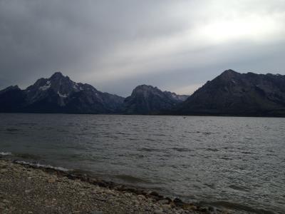
Description: Never Summer Wilderness and Bowen Lake viewed from Cascade Mountain, June 2024.

Image by Trellbailey – CC BY-SA 4.0 – Wikimedia

Never Summer Wilderness sign above Bowen Lake in Arapaho National Forest, CO.

Description: Never Summer Wilderness sign above Bowen Lake in Arapaho National Forest, CO.

Image by Trellbailey – CC0 – Wikimedia

View of the Never Summer Wilderness from the ridge of Cascade Mountain above Bowen Lake, taken on June 27, 2024.

Description: View of the Never Summer Wilderness from the ridge of Cascade Mountain above Bowen Lake, taken on June 27, 2024.

Image by Trellbailey – CC BY-SA 4.0 – Wikimedia

Search


Quick Links

National Parks (NEW)
National Forests (NEW)
National Monuments (NEW)
National Recreation Areas
State Parks
Bureau of Land Management (BLM) Areas
Wilderness Areas (NEW)

By The Numbers (NEW)
- Populations of all Countries (NEW)

Ideas - Stock Tickers
Running USA Debt Total